Spindletop Field Still Holds 1,259 Wells of Record, 126 Years On, Strata9 Data Show
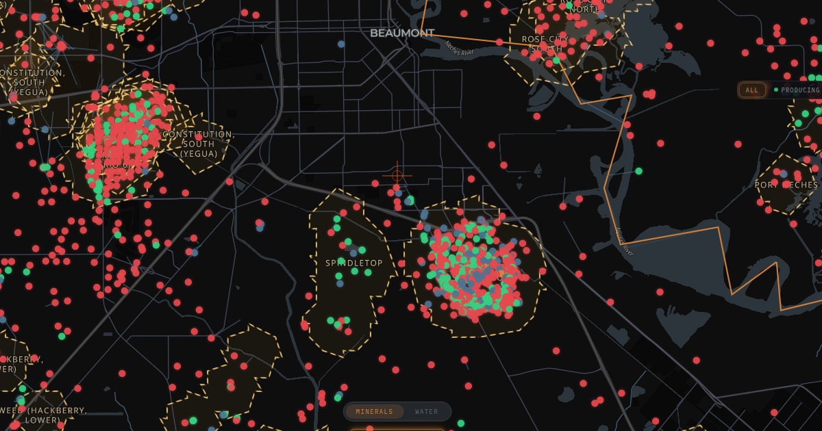
Strata9 maps 1,259 wells inside the Spindletop field boundary near Beaumont and 5,832 across Jefferson County, from plugged holes to wells still reporting oil today.
Drilling began on the Spindletop well near Beaumont on Oct. 27, 1900, 126 years ago this week, and the field it opened still carries 1,259 wells of record inside its mapped boundary, according to Strata9 data. Across Jefferson County, state filings compiled by Strata9 list 5,832 oil and gas wells.
For landowners, buyers, and operators around Beaumont, that history is not only a museum story. More than a century of drilling on and around the salt dome left a dense record of wells, and each one has a status that matters before a sale, a build, or a new permit.
What history records
As 12News reported, drillers led by the Hamill brothers worked the hill for about ten weeks before the Lucas Gusher blew in on Jan. 10, 1901, and 285 wells stood on Spindletop by 1902. The Handbook of Texas, published by the Texas State Historical Association, records that Anthony F. Lucas spudded the well on Oct. 27, 1900, with Al and Curt Hamill on the rig. It says the gusher came in at 1,139 feet and flowed an estimated 100,000 barrels a day until it was brought under control on Jan. 19. A second boom followed on Nov. 13, 1925, when the Yount-Lee Oil Company brought in a deeper well on the flank of the salt dome, according to the Handbook.
What the map shows today
Within Strata9's Spindletop field boundary, 406 wells, or 32.2%, are listed as plugged, 163 as dry holes, 124 as producing, 118 as permitted, 115 as cancelled, and three as shut in. Another 330 are listed as active with no production on file. Those 1,259 wells span 45 operators and 65 leases, and they account for 21.6% of all Jefferson County wells of record.
The field is still producing. Strata9 data carry 21 leases with Spindletop field names, and six of them reported a combined 3,145 barrels of oil in August 2026, the latest month on file, from four operators. One drilling permit inside the field boundary was issued in the past 365 days, to Rheaco Oil Company, Ltd. on its Gladys City lease in March 2026.
Countywide, 2,077 Jefferson County wells, or 35.6%, are plugged, 1,804 are dry holes, 542 are producing, 434 are permitted, 260 are cancelled, and 22 are shut in, with 693 listed as active with no production on file. The county file records 566 operators, 1,236 leases, 848 laterals, and 26 drilling permits issued in the past 365 days, according to Strata9 data.
How Strata9 helps
The Strata9 Oil and Gas map plots every Jefferson County well of record and lets users filter by status, including Producing, Shut In, and Plugged. Turning on the fields layer outlines Spindletop and neighboring fields, so a user can see where the old boom ground sits relative to a parcel, a pipeline route, or a new subdivision.
Each well card shows its status, well type, operator, lease, and, where the state records one, a plug date, along with lease production history. That lets a buyer near Gladys City or south Beaumont check which nearby wells are plugged, which still report oil, and which show no production on file.
On the go
The same map runs on phones through the Strata9 Android app on Google Play, so landmen, field crews, and property owners can check well status on site. Search Jefferson County directly at strata9.exchange/app.
Related coverage
- Drilling began 126 years ago today on the Spindletop well that made Beaumont the birthplace of the Texas oil industry · 12News (12newsnow.com)
- Spindletop Oilfield · Handbook of Texas Online, Texas State Historical Association