What Is Strata9? Inside the Map of 5,271,234 Wells
Strata9, the Zillow of the Subsurface, is a map-first subsurface intelligence platform and listing marketplace for oil, gas, minerals, royalties, leases and produced-water assets, with every well of record across 33 U.S. states, six Canadian provinces and territories, and the Gulf of America.
Strata9.exchange is the Zillow of the Subsurface, a map-first subsurface intelligence platform and listing marketplace for oil, gas, minerals, royalties, leases and produced-water assets. It is built by Strata9 Inc., a Houston, Texas company led by CEO and founder William Cormier. Strata9 is available free to the public.
The header reads: "Every well of record in 33 states, 5 provinces, 1 territory, 1 federal offshore area and 1 country" for a total of 5,271,234 wells. That coverage spans 33 U.S. states, six Canadian provinces and territories, and the Gulf of America.
Zooming into Midland County
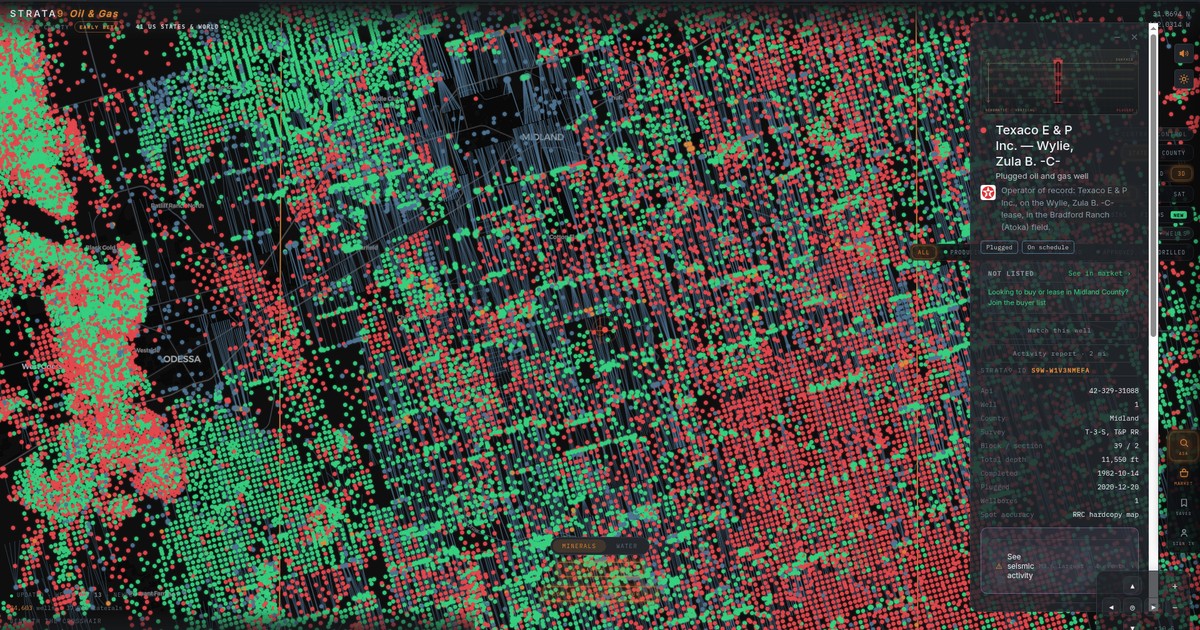
Zoomed into Midland County, Texas, the map fills with individual wells around Midland and Odessa. The app's Ask panel reports that "Midland County, Texas has 20,427 wells of record." Well filters across the map read ALL, PRODUCING, SHUT IN, PLUGGED and APPROVED, NOT DRILLED, and the LAYERS panel can narrow wells by orientation (All, Horizontal, Vertical) and by status (All, Producing, Shut-in, Plugged).
The Central Control switches between STATE and COUNTY views, 2D and 3D, and TERRAIN, DETAILED, TOPO and SAT base maps, with an overlay for BASINS or FIELDS. A banner shows how fresh the data is: "UPDATED · WELLS OCT 13 · NEWEST PERMIT OCT 9."
What a well card shows
Each well has its own card. One example is Texaco E & P Inc.'s Wylie, Zula B. -C- well, a plugged oil and gas well. The card lists Texaco E & P Inc. as the operator of record, on the Wylie, Zula B. -C- lease in the Bradford Ranch (Atoka) field, with Plugged and On schedule badges.
The card gives the well's STRATA9 ID (S9W-W1V3NMEFA), API number 42-329-31088, county, survey (T-3-S, T&P RR), block and section (39 / 2), total depth of 11,550 ft, a completed date of 1982-10-14, a plugged date of 2020-12-20, one wellbore and a spot accuracy of RRC hardcopy map. Its source line reads Railroad Commission of Texas, 2026-07-24.
The same card links to nearby seismic activity, listing 4 events with an M3.6 largest, and an OPERATORS IN THIS FIELD section showing 1 operator producing in Bradford Ranch (Atoka) for Jul 2026: Chevron, at 74.8 mcf/d of gas from 7 wells. A depth section draws a typical Midland Basin formation column against the well's 11,550 ft total depth, which the app labels as illustrative rather than a survey of the lease.
Each card also carries a market line (this well shows Not listed, with a link to See in market), along with Watch this well, Activity report, Navigate here, Share this well and Save to my list. The card invites users to sign in free to model a well's economics, follow it for new activity and save it to a list.
Standings, permits and more
Along the bottom, the EXCHANGE row opens TAPE, WATCH, MOVERS, RANKS and PRICES, and the COMMAND CENTER opens WELLS, PERMITS, PIPELINES, SEISMIC, WHERE I AM, MEASURE, PINS, KEY and ASK Strata9. A MINERALS and WATER toggle sits alongside, and the right rail holds ASK, MARKET, SAVED and SIGN IN.
RANKS opens the STANDINGS view for May 2026 through Aug 2026, using each state's latest reported month, with OIL and GAS, ALL STATES or COUNTY, and tabs for RANKS, GAINERS, DECLINERS, OPERATORS and HEAT MAP. For oil, it shows 359.67M bbl a month reported across 242,196 wells and leases, down 1.9% month over month among the 238,999 reporting both months, with 20,373 advancers and 31,149 decliners. Seminole San Andres Unit, listed under Amerada Hess Corporation in Texas, ranks first at 745.5K bbl a month, up 9.8%.